
Guiding Principles
Guiding Principle 3:
Build a climate-ready New York City
The City aligns capital investments with climate sustainability and resiliency goals. We prepare for the impacts of climate change on capital projects with long useful lives through continued investments in resilient infrastructure, facilities, and natural areas citywide. Infrastructure projects are viewed through the lenses of how they reduce carbon emissions and energy consumption, generate renewable energy, mitigate flood risk, improve coastal protection, address heat vulnerability, protect public health, and achieve environmental justice for all residents.
Climate Budgeting to align resources with sustainability and resiliency goals
To ensure we remain focused on prioritizing climate change and environmental justice in our investments and decision-making, New York City will be the largest city in the nation and one of the world’s first global cities to launch a Climate Budgeting initiative. Climate budgeting incorporates science-based climate considerations into the City’s budget decision-making process. A climate budget publication coming in April 2024 will highlight the City’s new and ongoing investments and provide a snapshot of the projected impacts of our collective actions on the path toward meeting long-term climate goals.
The City oversees a multi-billion-dollar capital portfolio that shapes our buildings, transportation, recreational spaces, energy supply, and infrastructure. Some investments are specifically intended to reduce emissions or increase resiliency. Other projects, such as increasing affordable housing, maintaining infrastructure in good repair, and procuring food for students, indirectly impact our climate goals. Climate budgeting will help us understand the potential for each of our investments to keep us on course.
Moving toward resilient and sustainable infrastructure
In April 2023, MOCEJ released the City’s strategic climate plan – PlaNYC: Getting Sustainability Done. Published every four years since 2007, the strategic climate plans have transformed New York City and improved New Yorkers’ lives by increasing livability, sustainability, and resiliency across the five boroughs. The City has used these plans to implement bold, new ideas and advance environmental justice work already happening in city agencies across sectors including energy, green space, transportation, coastal protection, and buildings. The plan demonstrates how the City will “get stuff done” on climate, center equity, and improve residents’ lives today, while also looking toward long-term sustainability, resiliency, and climate and environmental justice in our city
Climate change hazards including extreme heat, heavy precipitation, chronic tidal flooding, and coastal storm surge affect New Yorkers now and are anticipated to become more frequent and severe in the coming decades. Our facilities and infrastructure must be made resilient to a changing climate, including retrofitting existing assets and constructing new ones to withstand natural hazards. New assets must be designed based on the latest climate projections, to function as intended throughout their useful lives as climate events intensify. As discussed in Investment Priority 1 on page I-29, the City’s Climate Resiliency Design Guidelines provide a set of standards for ensuring that our buildings and infrastructure meet these new challenges and will withstand the increased stress due to extreme weather and climate change. All new construction and substantial retrofits will use these standards by 2027.
Another way the City is moving toward a more resilient and sustainable infrastructure is through the Climate Strong Communities program, which will invest in communities unaddressed by Hurricane Sandy recovery funding, focusing on environmental justice neighborhoods. This program will create multi-hazard resiliency and sustainability projects by targeting federal and state funding opportunities. These projects will be constructed in the near term and center on neighborhood needs. Early focus areas will include Soundview (BX), Corona (QNS), Brownsville (BK), Port Richmond (SI), Canarsie (BK), and East Harlem (MN).
Improving coastal resiliency
Since Hurricane Sandy, the City, in partnership with state and federal agencies, has completed several coastal flood protection projects. In Queens, these collaborations include the reconstructed Rockaway Boardwalk, a wetlands restoration project and street raisings in Broad Channel, and beach renourishments between Beach 92nd and Beach 103rd Streets. In Brooklyn, a T-groin project in Sea Gate is complete. Projects spanning multiple boroughs include 26 completed Bluebelt projects and the NYCEM Interim Flood Protection Measures program, which now covers more than 55 sites citywide.
The City has also started construction on multiple large-scale coastal flood protection projects including the East Side Coastal Resiliency (ESCR) Project as part of the larger Lower Manhattan Coastal Resiliency (LMCR) Project. LMCR is an integrated coastal protection initiative aimed at protecting one of the City’s major job centers from rising sea levels and stronger coastal storms. Besides ESCR, LMCR includes Brooklyn Bridge-Montgomery St., Financial District-Seaport, The Battery, and Battery Park City Coastal Resilience Projects. The City is also working with the US Army Corps of Engineers on a coastal flood protection project in the Rockaways and an integrated levee and seawall system to protect the South Shore of Staten Island from storm surge. The flood protection will be buried under naturalized dunes and an accessible boardwalk which will provide public access and recreation along the beach.
East Side Coastal Resiliency Project
The East Side Coastal Resiliency (ESCR) Project is a one-of-a-kind coastal protection initiative aimed at reducing flood risk due to coastal storms and sea level rise on Manhattan’s East Side from East 25th Street to Montgomery Street. Currently, under construction, the project will provide flood protection for 110,000 New Yorkers, including approximately 28,000 NYCHA residents. The project will also offer protection to critical infrastructure including local schools and libraries as well as improve access to the waterfront by reconstructing new pedestrian bridges that meet universal accessibility standards. ESCR will create a 2.4-mile flood protection system consisting of above- and below-ground floodwalls and floodgates that will be blended into the fabric of the community by integrating with local streets, the elevated East River Park, and the new landscape surrounding Corlears Hook Park, Murphy Brothers Playground, Stuyvesant Cove Park, and Asser Levy Playground. Elevating the park and diversifying plant species will yield an ecosystem more resistant to salt exposure and will improve resiliency and post-storm functionality over the long term. The project will also involve significant investments in underground interior drainage improvements that will improve the capacity of the sewer system.
The East Side Coastal Resiliency Project rendering
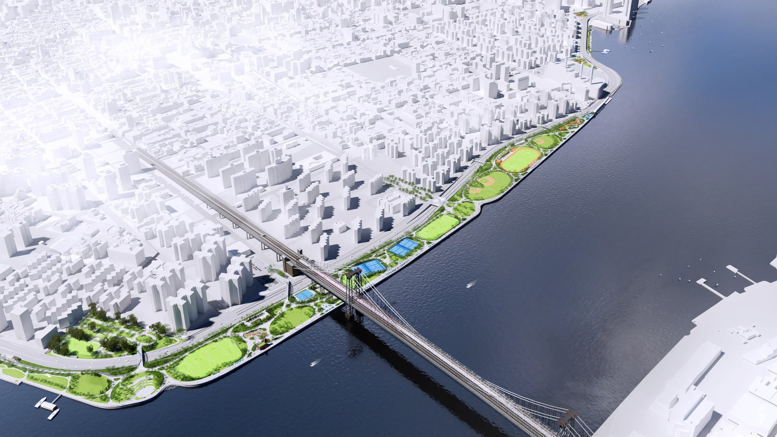
- Source: MOCEJ
Understanding and mitigating flood risk for essential city assets
New York City is using a multi-layered strategy to prepare for extreme rainfall and manage stormwater to improve the health of our local waterways and prevent flooding. Flooding from extreme rain can happen in coastal and inland areas, with low-lying and highly impervious areas at greater risk. Over the last three decades, the City has transformed its approach to stormwater management and resilience to extreme rainfall.
In partnership with the City University of New York and New York University, the City launched FloodNet, a cooperative of communities, researchers, and New York City government agencies that work to better understand the frequency, severity, and impacts of flooding in New York City. MOCEJ will install 500 flood sensors in the most vulnerable areas across the City for real-time data collection by 2027, providing both real-time flooding information to officials and residents and a hyperlocal historical record of flooding that can be used to inform future mitigation efforts.
Cloudburst Management
New York City is incorporating cloudburst design principles into city construction, starting with the most vulnerable areas. Cloudburst management implements a combination of methods that absorb, store, and transfer stormwater to minimize flooding from heavy rainfall events. Using grey infrastructure, like sewer pipes and underground storage tanks, and green infrastructure, like trees and rain gardens, cloudburst management can minimize damage to property and infrastructure by reducing strain on the sewer system. The TYCS allocates an additional $400 million to support four new locations for Cloudburst projects in Corona and Kissena Park, Queens, Parkchester, Bronx, and East New York, Brooklyn. They join the City’s ongoing work in South Jamaica and St. Albans, Queens, and East Harlem, Manhattan. In 2023, NYCHA announced progress on cloudburst management at eight NYCHA developments. Cloudburst Management As part of the green infrastructure program, DEP, DOT, and NYC Parks have updated their design guidelines to incorporate more porous pavement to manage the runoff from precipitation that falls on our streets and sidewalks. Porous pavement has been installed at 33 parks across the City, with plans to add nearly 30,000 square feet in 10 additional parks by 2026. Bluebelts are another ecologically rich and cost-effective mechanism for reducing urban flooding. The program connects lakes and streams to storm sewers to provide a natural path for stormwater. The City has completed 84 Bluebelt projects across three boroughs. The City has also piloted stream daylighting, the process of removing any obstructions covering a natural water stream, to capture and manage stormwater using large-scale nature-based measures.
Addressing heat vulnerability
Climate change is causing more frequent and intense heat waves. On average, more people die annually from extreme heat than from all other types of extreme weather. But heat deaths are preventable. New Yorkers remain more vulnerable to extreme heat than people in surrounding non-urban areas, due in part to the physical makeup of our city — impervious surfaces and sparse vegetation which contribute to trapped heat and higher temperatures. Seniors and those with certain health conditions are more vulnerable to heat stress, and low-income residents are more likely to live in areas that trap heat and less likely to have access to air conditioning.
New York City is adapting the built environment and public realm to address these compounded physical and social stresses. Cool It! NYC is a citywide plan to increase the cooling features available to the public during heat emergencies, particularly in neighborhoods that face enhanced danger from high heat. NYC Parks’ Cool It! NYC map shows water features, drinking fountains, and trees across the City. The City also operates an extensive network of cooling centers, primarily in libraries, community centers, and senior centers, which offer safe, free access to cooling during heatwave events. Additionally, through its Cool Corridors project, DOT is developing a toolkit of interventions and best practices that are designed to mitigate the effects of heat on urban streets and sidewalks.
For information on how the City is promoting energy efficiency, see Investment Priority 1.
DOHMH Heat Vulnerability Index
The City recognizes that heat-related health impacts are unfairly distributed across our neighborhoods. DOHMH, along with Columbia University, developed the New York City Heat Vulnerability Index (HVI) to measure how the risk of heat related illness or death varies across the City. The HVI uses a statistical model to summarize the most important social and environmental factors that contribute to neighborhood heat risk. Environmental factors include measurements of surface temperature and green space, while social factors include access to home air conditioning, the percentage of residents who are low-income, and the percentage of non-Latinx Black residents.
Differences in these risk factors are rooted in past and present systemic inequities, including racism. The HVI ranks each neighborhood from 1 (lowest heat vulnerability) to 5 (highest). The City has prioritized heat mitigation resources and programs in neighborhoods ranked 4 or 5 as the most heat-burdened communities. Since 2017, 70% of new cool roofs – energy-saving reflective rooftops – have been installed in high HVI areas. Also, the City has committed an additional $112 million for the program to plant an estimated 36,000 additional trees per year in HVI-4 neighborhoods through 2026. Communities can also use the HVI to advocate for other services and resources that can enhance resiliency to heat.
DOHMH Heat Vulnerability map
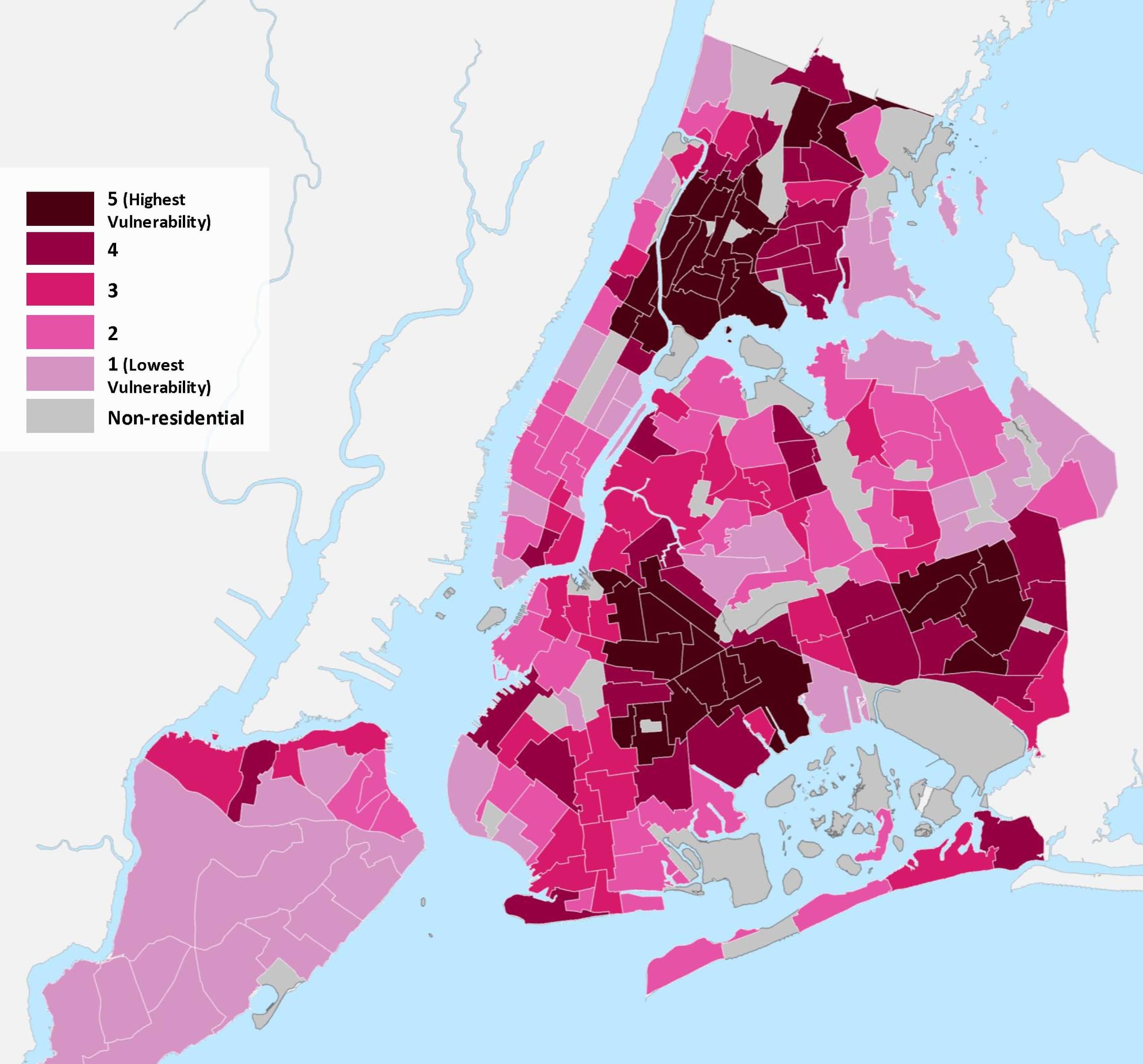
- Source: DOHMH, 2018 Neighborhood Tabulation Areas (NTAs)