Key Investments
2. Condition of City Facilities and Infrastructure
4. Education and Cultural Resources
5. Public Health and Safety
Public Health and Safety
The city’s Capital Strategy is guided by a commitment to creating a built environment that supports safe, healthy lifestyles for all New Yorkers and ensuring essential services and facilities for public health and safety. To achieve this, the city will continue to strengthen the health and hospital system, improve the quality of and access to outdoor public space, invest in heat mitigation and cooling infrastructure, enhance efforts to fight crime and gun violence, and continue to improve the city’s multimodal transportation network.
Strengthening the City’s Health Systems
NYC Health + Hospitals (H+H) is the nation’s largest municipal health care delivery system in the United States dedicated to providing the highest quality health care services to all New Yorkers and plays a critical role in addressing longstanding health inequities. H+H is making investments through its hospitals and facilities to improve safety, patient comfort, and operations including state of good repair and life safety projects for building systems as well as updating technology equipment to ensure secure and seamless healthcare services. For example, the city is investing $14 million in 2026 for the Far Rockaway Primary Care Center to expand primary care services and improve local community access to comprehensive healthcare, with a focus on serving underserved populations.
DOHMH works to strengthen our public health system through investments and a framework to improve overall health outcomes and reduce premature death. Important to this mission is investing in our network of primary care centers. For example, the city is also investing $16 million in building rehabilitation and restoration at the Washington Heights Family Health Center and $18 million on interior and exterior renovation at the Morrisania Health Center. These investments will create improved facilities and a more welcoming environment for patients and staff.
It is also crucial to strengthen the city’s ability to face public health crises in an effective and equitable manner. Formally known as the Pandemic Response Institute (PRI), the NYC Preparedness and Recovery Institute, launched in 2022 through an interagency collaboration among NYCEDC, DOHMH, and New York City Emergency Management Department (NYCEM) with a contingent city capital award of $3 million. Led by ICAP at Columbia University in partnership with the CUNY Graduate School of Public Health and Health Policy, the institute is embedded within the public health infrastructure. Its primary goal has been to ensure that all New Yorkers have access to health solutions, information for decision-making, and the capacity to prepare and respond to public health emergencies.
In the last three years, the PRI has developed data-sharing programs, funded new tools and technologies to enhance emergency preparedness, and advanced epidemiological modeling to better predict and respond to infectious disease and climate-related threats.
DOHMH Public Health Laboratory
The NYC Public Health Lab has been active in protecting and promoting public health in New York City for over 125 years, and this added investment will ensure that their work remains on the cutting edge of public health practice for decades to come. EDC and DOHMH have partnered to construct a new 10-story, 240,000 square feet Public Health Laboratory on the Harlem hospital campus, which will replace the aging facility in Kips Bay and is expected to be substantially completed in the summer of 2025. The new Public Health Laboratory will enhance the city’s capacity for clinical and environmental testing, disease surveillance, and emergency response.
The new Public Health Laboratory will also benefit from a $43 million city investment in 2026 to make the new facility one of the most energy efficient and high tech of its kind in the country.
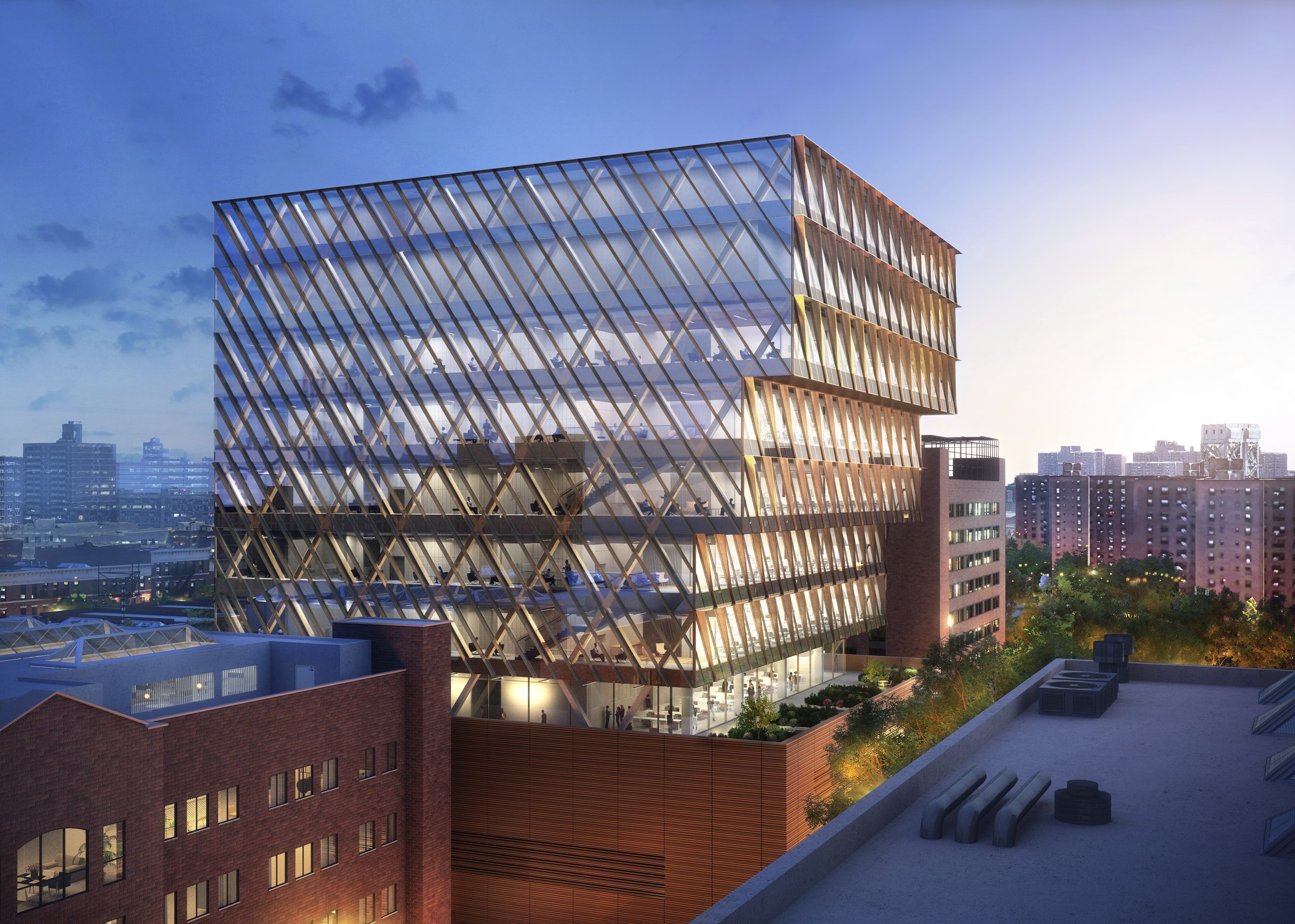
- Images credit: Skidmore, Owings & Merrill (SOM)
Investing in housing for health
Stable and environmentally safe housing is critical to support the well-being of New Yorkers. The city is investing in multiple programs to make sure the city’s affordable and stabilized housing stock continues to provide safe and healthy living spaces, and that adding supportive housing for New Yorkers with intensive health needs remains a priority.
NYC Health + Hospitals recognizes that homeless individuals suffering from chronic health issues cannot be treated effectively without stable housing. H+H’s Housing for Health is a comprehensive initiative to serve the health system’s large patient population experiencing homelessness by connecting them with housing supports. H+H has four strategic areas of focus: (1) housing navigation services, (2) medical respite beds, (3) social service supports for patients in permanent housing, and (4) new supportive and affordable housing on hospital land. Over the next five years, H+H plans to leverage additional land to create nearly 650 new affordable homes, which will deliver continuity of care for vulnerable New Yorkers. The development of the new apartments are currently in the HPD project pipeline. Going forward, H+H will continue to assess underutilized land to deliver on the city’s commitment to housing and health.
Environmental Testing Programs for NYCHA Developments
Lead is a toxic metal commonly found in paint used in buildings constructed before 1978 and is shown to cause serious health problems. Under NYCHA’s lead program, the Authority tests all apartments for lead-based paint. Following testing, NYCHA abates all apartment units that surpass the legal 0.5 mg/cm2 threshold determined through testing. The abatement phase involves the removal of all lead-based paint and lead dust hazards, replacement of components painted with lead-based paint, clean-up, disposal, post-abatement clearance testing, and all measures associated with restoring the apartment unit. This work is conducted by an EPA-certified abatement firm and utilizes the removal method only, as opposed to enclosure or encapsulation of the lead. NYCHA expects to complete testing of all units by the end of 2026 and continue their abatement work through 2039. There is $450 million in city capital in the TYCS for this work.
Additionally, the Vacant Unit Readiness program prepares vacant housing units for occupancy by ensuring the units are in good repair, free of safety hazards, and ready for new tenants. This may include environmental remediation of asbestos, which is a naturally occurring fibrous silicate mineral found in two primary building materials: vinyl asbestos floor tiles and ceiling coatings that have been applied to concrete ceiling decks of apartment units. As NYCHA completes apartment repairs and refurbishments to ready the unit for new tenants, these asbestos-containing materials can be agitated creating an airborne exposure risk to incoming tenants. NYCHA’s programmatic approach to asbestos remediation involves testing, abatement, and air monitoring. If a unit tests positive, the materials are removed and NYCHA safely disposes of the asbestos. Once the materials have been removed, NYCHA conducts air monitoring to confirm that the unit is safe for occupancy. The TYCS allocates $179M in city capital towards this work.
Therapeutic Housing Units for Essential Health Services
The city is making important investments into medical care and supportive housing for patients with specific needs. In 2026, NYC Health and Hospitals together with Correctional Health Services (CHS) is investing $235 million into Outposted Therapeutic Housing Units at Woodhull Hospital and North Central Bronx Hospital. This investment will support the development of specialized housing units at Woodhull and North Central Bronx to provide intensive medical and mental health care for incarcerated individuals.
These units will house CHS patients who do not require inpatient admission but would benefit from close, regular access to specialty and subspecialty care available in the hospitals. This unique model of care will increase patients’ access to chemotherapy, radiation therapy, and other kinds of specialized treatment and equipment.
Improving and expanding outdoor public space
Investments in outdoor public space is an investment in health. The city’s parks, plazas, sidewalks, and even streets provide essential safe space for recreation, exercise, and socializing.
The Parks Department works to strategically allocate resources to maintain existing parks resources and improve the quality, accessibility, efficiency, and sustainability of the city’s park system. The Community Parks Initiative guides investment in public parks in neighborhoods that are densely populated, growing, and contain higher than average concentrations of poverty. In order to close gaps where residents are living further than a walk to a park, the city is using multiple strategies to increase access, including partnerships with public and private institutions and acquiring private property to create new parks.
The Department of Education (DOE) and SCA have partnered to renovate, open or maintain outdoor recreational facilities such as playgrounds and athletic fields that serve both students and local residents during non-school hours to improve open space resources for students and communities. City programs also support the transformation of existing assets into multifunctional outdoor spaces, such as the DOT Open Streets program which opens pedestrian space by closing streets to car traffic and is being expanded to increase participation of historically underserved neighborhoods. DOT is also committing capital funds to make the city’s most successful Open Streets locations permanent, including 34th Avenue and Woodside Avenue in Queens, Willis Avenue in the Bronx, Underhill Avenue in Brooklyn, Minthorne Street in Staten Island, and Dyckman Street (Quisqueya Plaza) in Manhattan.
Open space investment and access is a priority in planning for large-scale neighborhood change. The city has continued to work on plans for future additions to the city’s public space through neighborhood plans, including the Gowanus Neighborhood Plan which will generate nearly six acres of new public parks and open space with waterfront esplanade areas elevated to respond to long-term daily tidal flooding. The zoning framework for the plan also creates incentives for private developers to incorporate community amenities like comfort stations, boat launches, and historic interpretation elements. The plan also calls for public investments in new waterfront open space, city-owned street ends, and design interventions around bridge crossings to support the overall vision of a safe, resilient, and active waterfront esplanade.
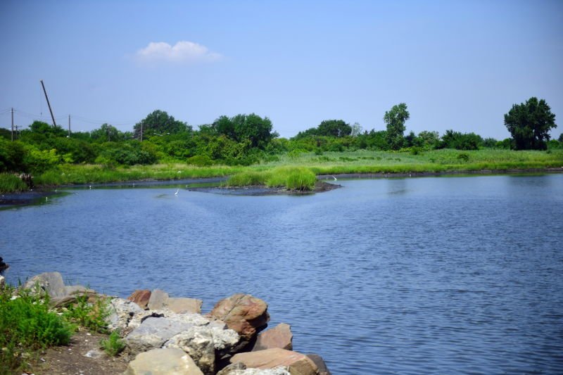
Arverne East Nature Preserve
The Arverne Urban Renewal Area (URA) is a 308-acre area on the Rockaway Peninsula located towards the eastern end of the Rockaway Peninsula. The city acquired this land in the 1970’s, and the land sat predominately vacant for approximately 50 years. The Arverne East Nature Preserve, a 35-acre protected ecological area will harbor maritime flora and fauna as well as a place for visitors to recreate and learn. The Nature Preserve is the first phase of a larger plan within the URA to create a deeply affordable housing development in partnership with HPD, a local farm, local retail, and numerous additional public open spaces.
As part of the project, nearly four acres of existing impervious surfaces will be removed and replaced with natural beach sand and native plantings. Non-native, disturbed or poor-quality habitats will be restored to naturalistic conditions, attracting wildlife through an improved diversity of plant species, including native grassland, shrubland, maritime woodland, and wet meadows. New plantings will increase the volumes of native and coastal plant communities that are already successfully established at the site. This project will also include the construction of a multi-purpose building that will be located on the eastern side of Beach 44th Street across from the main entrance to the Nature Preserve and adjacent to the outdoor recreational spaces to the east. The building will measure approximately 3,000 square feet and a portion will contain restrooms, storage, and administrative space to be used and managed by NYC Parks in connection to the Nature Preserve operations. The balance of the space will comprise additional restrooms and office space associated with the programmed recreation space to the east and will also include community space intended to be available to local community-based organizations on an as needed basis.
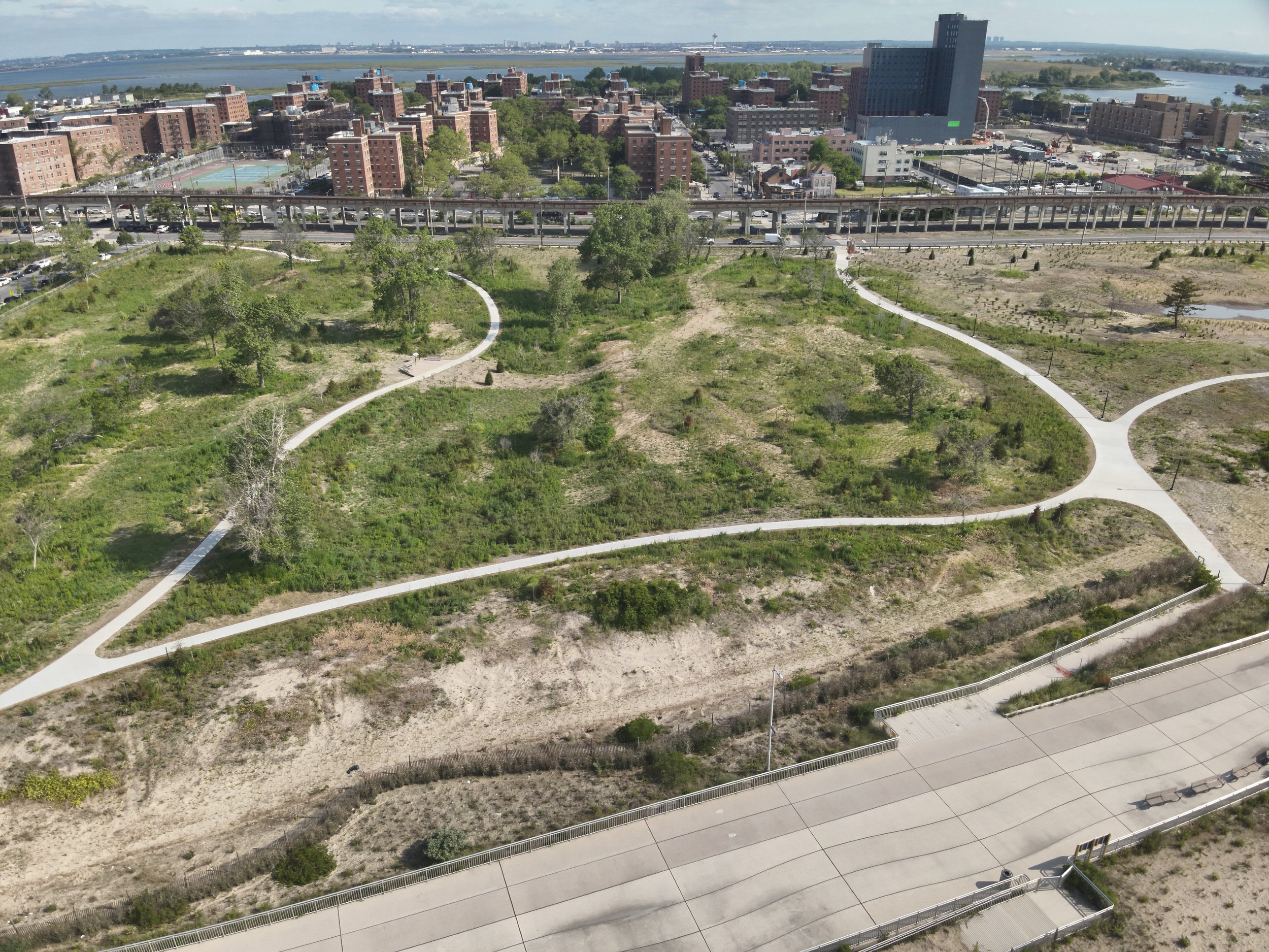
- Image credit: Triangle Equities, 2024
Stronger Parks/Safer Communities - Quarry Ballfields
The Quarry Ballfields in the Bronx is a lively center of activity for the surrounding neighborhood, especially for little league teams. Last renovated in 1998, the city is investing $7.3 million to make improvements including a synthetic turf soccer field and sitting area. This project, which is nearly complete, is part of NYC Parks’ Stronger Parks/Safer Communities initiative, a $400 million investment that focuses on upgrading recreational facilities and amenities in neighborhoods affected by high rates of gun violence. It also includes outdoor public programs to activate parks, foster community connections, and enhance safety, health, and quality of life.
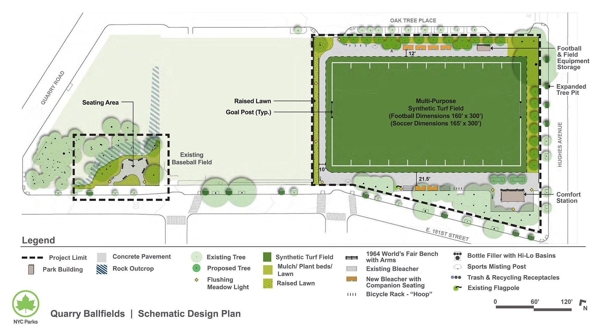
- Image credit: NYC Parks Capital Project TrackerP
Investing in a network of green infrastructure
In addition to expanding recreational space, the city is pursuing strategies to use open space and natural areas to soak up water and reduce pollution from stormwater runoff. The city envisions protecting approximately 2,800 acres of fragile wetlands and streams on parkland through the early 2050s as part of Parks’ Wetlands Management Framework. These natural area restorations are paired with investment in the city’s urban infrastructure to create a network of nature-based solutions to the impact of extreme weather and a changing climate. Green streets, rain gardens, bioswales, and permeable pavement projects are being implemented and planned throughout the city’s streets and dense urban areas to capture stormwater, provide small habitats, and clean runoff.
The city builds and manages ecological and infrastructural mechanisms for stormwater management to divert additional rainfall away from sewers. One type of stormwater management tool is bluebelts, which are preserved and enhanced natural drainage corridors such as streams, ponds, and wetlands intended to store, filter, and convey runoff. Another is cloudburst management systems, which are designed to mitigate the impacts of high-volume and especially sudden rainfall by combining green infrastructure with supplementary sewer additions to retain water until the normal sewer system can again handle the added flow.
These infrastructure interventions are at times integrated into larger open space projects, such as the East Side Coastal Resiliency project which integrates floodwalls, berms, and flood gates into planned improvements to recreational space.
Spring Creek North Salt Marsh Restoration
NYC Parks is undertaking a $100 million Growing Wetlands, Gaining Resiliency initiative to protect and restore the city’s coastal and freshwater streams and wetlands, preserving biodiversity, reducing flood risks, mitigating extreme heat, storing carbon, and offering natural open spaces. As part of this initiative, the city is investing $19.5 million into the Spring Creek North to remove historic fill and restore the salt marsh in this area on the border of Brooklyn and Queens. Parks, together with the US Army Corp of Engineers and New York State Department of Environmental Conservation will excavate landfill dumped around the marshland, facilitate a natural intertidal landscape, and restore natural species. To enhance effectiveness and improve the health of the watershed, berms, reforestation, and stormwater detention mechanisms are planned for the north end of the salt marsh restoration project.
- Image credit: NYC Parks/Malcolm Pinckney
Enhancing public safety
The city is focused on improving public safety facilities to strengthen relations between the community and police. The NYPD renovated it’s 40th and 116th precinct buildings to provide state of the art facilities for officers as well as comfortable and welcoming spaces for community members. The 40th precinct introduced the first ever community event space inside of a precinct to highlight collaborative efforts between community and the police in order to encourage stronger relationships and create safer streets. Both buildings promote environmental sustainability through features that include green roofs to reduce stormwater runoff, and high efficiency fixtures to reduce energy usage and solar panels.
Improving the city’s multimodal transportation network
Over the next decade the city will invest in interconnected transportation options to help even more New Yorkers access essential services, go to work, and move about the city. The TYCS includes $5.5 billion for street reconstruction with approximately $3 billion allocated for Vision Zero, which was implemented in 2014 and directs resources to much- needed safety improvements to streets, bike lanes, and pedestrian walkways. Between 2014 and 2024 pedestrian fatalities nationwide increased by 48 percent. However, during that same period, pedestrian fatalities in New York City has fluctuated but remained relatively steady. In February 2023, DOT released a new Borough Pedestrian Safety Plan, which outlines the next set of streets, intersections, and areas that will be the focus of Vision Zero initiatives. In March 2025, DOT released a new Vision Zero Initiative to increase the public’s access to traffic safety messages on street light poles and city-owned buildings across the city. This latest iteration maintains the project’s aim of improving street redesign for public safety, install and monitor speed and red-light cameras, and conduct public education to complement Vision Zero work.
The city continues to enhance the pedestrian, transit, and bicycle network as part of 2019’s NYC Streets Plan legislation.
In the Making New York Work for Everyone action plan, the city promised it will embrace a broad range of transportation improvements so people and goods can get to their destinations faster, more reliably, and more sustainably. In September 2023, DOT released its Curb Management Action Plan to improve the way curb uses are regulated, priced, programmed, and enforced. Working with business improvement districts and other neighborhood organizations, the agency piloted model curb management strategies and implemented a data driven and technology-based enforcement and reservation system. Furthermore, through the Smart Curbs program, the agency prioritize safety and curb uses based on community needs.
The city continues to invest in NYC Ferry, which connects often transit deprived neighborhoods to job centers and brings much needed transit access to NYC’s waterfront and recreational areas. Critically, Mayor Adams’ NYC Ferry Forward plan supports a more equitable, accessible, and financially sustainable system. To accomplish all of these goals, the city has invested in a fleet of vessels, homeport and maintenance facilities, multiple landings throughout the city, and state of good repair needs that take into account demanding maritime environments.
Manhattan Waterfront Greenway - Inwood
The Manhattan Waterfront Greenway - Inwood Upland Routes project (Inwood Greenway) is a transformative project that developed from more than a decade of public outreach. Planners took this feedback and aligned it with multiple local and federal initiatives to create the $180 million Inwood Greenway project. This project also falls within DOT’s highest priority investment areas established in the NYC Streets Plan.
This project began by focusing on intersections that communities identified as a concern, which were then compared with, Vision Zero data. Many of these intersections were along the 10th Avenue corridor, which became identified as a route for the Manhattan Waterfront Greenway: a greenway loop that would encircle the entire Island of Manhattan. As a result, 1.5 miles of protected bike lanes will enhance connectivity to The Bronx and within the Inwood neighborhood. Greenspace will be added along these corridors and the intersections originally identified by the community will be normalized to slow motor vehicles and shorten crossings for pedestrians. This project will also raise part of 10th Avenue near Sherman Creek to prevent inland flooding that has been occurring and will be exacerbated with sea level rise. Currently this project is in a design procurement phase.
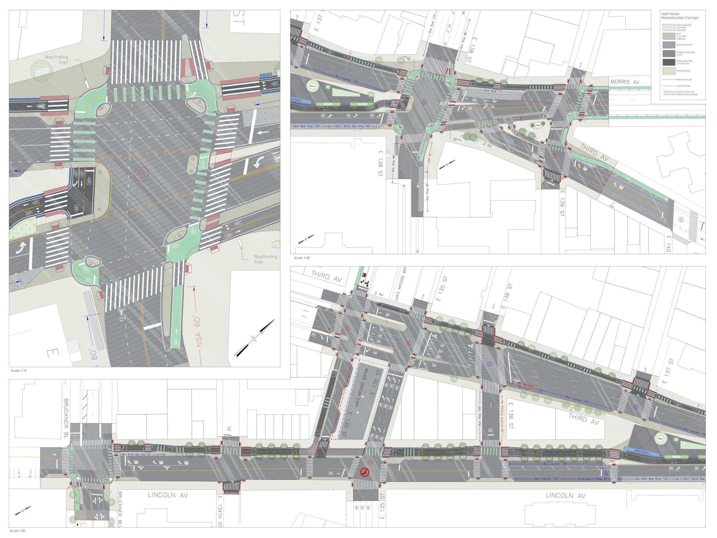
Mott Haven Pedestrian and Cyclist Improvements
The city is committed to improving street safety for all street users, fostering shifts to sustainable and healthy modes of transport, and concentrating financial resources in communities that have suffered historical disinvestment. To advance this mission, the city funded the Mott Haven Pedestrian and Cyclist Improvements project, which will bring much needed capital investment to this historically underserved community in the South Bronx. This DOT capital project on Third Avenue between East 135th to East 139th will reinvigorate a commercial corridor and transit hub by improving circulation and pedestrian safety, improving access to transit and cycling options, enhancing the appearance of the public realm.
Building upon the success of DOT’s in-house street improvement project at Third Avenue, Morris Avenue, and East 138th Street, the Mott Haven project supports permanent safety improvements with connections to the Third Avenue Bridge to Manhattan. In addition to facilitating walking and non-motorized cycling trips, this project will improve bus service and provide access for disabled persons by constructing bus bulbs – sidewalk extensions that don’t require buses to exit the travel lane to access a protected loading area – to facilitate safe, accessible boarding of the Bx2, Bx32, and Bx21 buses. The project will reclaim space in the right-of-way for pedestrians and cyclists, reshape intersections, shorten pedestrian crossings, and raise the southbound bike lane on Third Avenue to sidewalk height. The turn lane separates from the intersection at East 137th Street between Third Avenue and Lincoln Avenue will be closed to vehicular traffic and Graham Triangle will be expanded. This closure will connect the pedestrian network along the east side of Third Avenue and drastically increase pedestrian space. Curb extensions will be constructed at all pedestrian crossings to shorten crossing distances and increase pedestrian visibility.
- Image credit: DOT